

Select Clients and Projects
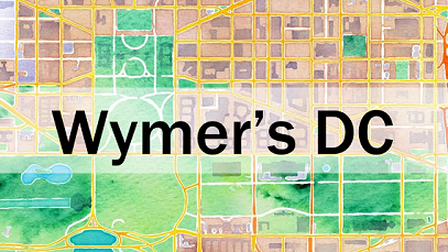
Wymer's DC
Wymer's DC is a digital map which re-contextualizes the photographs of John P. Wymer through a geo-spatial lens and grounds them with modern-day image comparisons. The 4,000 images in the Wymer Collection are owned by the Historical Society of Washington, D.C.
This project was created as a collaboration between the Historical Society and Jessica and Thomas Smith of the HistorySmiths.
Wymer's DC has been widely featured since it premiered in Spring of 2016, appearing across media outlets such as CityLab, Channel WUSA9, and more. Wymer's DC has been featured in presentations at the Historical Society of Washington, D.C., The George Washington University's Museum Monday lecture series, and the 43rd Annual Conference on D.C. History.

FlipKit
FlipKit is a custom software for map interfaces, characterized by a built-in toggle mechanism which allows users to rapidly flip between modern Google Street View images and another image assemblage of their choice which is overlaid on Google Street View. FlipKit was designed in order to provide users with contextual foundation for an historic image collection, but can be applied to image suites from any field.
FlipKit was designed as a way to provide greater accessibility to beautiful and informative historic photograph collections that are currently being underutilized due to a lack of easy access to the public. Historic photograph collections are a valuable component of our present and FlipKit allows for easier access to the images while at the same time rooting them in their geographic context.
The FlipKit software is open source under the terms of the MIT License.

HomeBass
HomeBASS is a software designed to streamline the move process of library and museum collections from one location to another. The software uses a box-level inventory and shelving schematics to configure and pre-assign box placements for the new shelving systems prior to the move. This software accounts for the nuances of a GLAM move by factoring in oversized material, collection growth, different shelf types, and variable usable linear feet dimensions.
ArchiBox Labeler
ArchiBox Labeler is a custom software application designed to efficiently and accurately label archival boxes. The software was created in 2017 to aid in the rapid labeling of boxes within an archival repository prior to a facility move. It was developed quickly in response to the immediate need and was in use within 3 days of the initial request.
This software comes with a template that can be tailored to each user. It can generate labels of many sizes and be formatted for specific needs. New templates coming soon! See newly supported box types and dimensions.
Kiki Messaging Service
Kiki is a direct messaging poetry robot. Each Kiki-type model comes with an e-ink screen, a dedicated phone number, a website with admin-controllable settings, and the possibilities for boundless rhyming joy.
Named after Miyazaki’s Kiki’s Delivery Service, we hope that your Kiki device will bring you lots of joy as a fun platform for family and friends to send cheerful rhymes.
Kiki’s lexicon is built from Carnegie-Mellon University’s Pronunciation Dictionary (CMUdict). She understands the phonetics of over 134,000 words using standard North American phonemes. The rhyme detection is based on the Dandelion library.
Inquire for details on getting your own device and learn more at Kiki.group.

Randulist
This web site will take your list of items, shuffle it, an give you a single element at a time. It was developed to randomize a list of countries to cook cuisines from every week.
The advantage of this application over other randomized listing sites is that the items you have already seen will not be produced again (until the list cycles all the way around). You can also share your list's URL with someone else, and they will see the same progression as you.
Bloomington Balloon Rides
This website was designed by the HistorySmiths for an Indiana Hot Air Balloon company in order to advertise commercial ride services. The site combines the gorgeous aerial photography of the ballooning community with functional business services like online booking, an integrated calendar, and point of sale (POS) system.
The integration of these new services streamlined business services and continues to be a great asset to this small business owner.

International Space Station Collaboration Map
This map is a visualization of scientific collaborations based on the International Space Station (ISS). When two or more people publish a paper based on ISS research, they are linked with a line on this map, with the color indicating the discipline (for example, green is Biology). The global view emphasizes the international scale of the collaboration and the space-based platform. This project was used in posters and materials supporting continued NASA funding for the Space Station.
This map was created by Thomas for the Center for Knowledge Diffusion.